
If you live in close proximity of the Atlantic Ocean or the Gulf of Mexico (within several hundred miles at least) then you know that each year from late May until the end of November you are living through hurricane season. Storms develop and some will quickly disappear while others gain strength and take aim for the coastal regions of the U.S. The National Hurricane Center and NOAA are able to predict the track and arrival of storms with precise accuracy; however, the storms often have a mind of their own and change paths with no warning. Watching and being prepared is essential during these months.

I’ve always been fascinated by these powerful storms. Perhaps it is because as a baby my mother and I “rode out” Hurricane Audrey while my then AF pilot father flew a plane to safety. I don’t remember it, but as Hurricane Katrina was approaching the coast in 2005 I called my parents in Jackson Mississiippi to make sure they had left and was surprised when my mother answered the phone. After my question of why haven’t you left, why are you staying she calmly replied that they were prepared. Daddy had charged up the cell phone and had gone to get a bag of ice, just in case. She reminded me that this wasn’t the first hurricane they had “ridden out”. I would watch it on television as it reeked its destruction on the Gulf Coast.

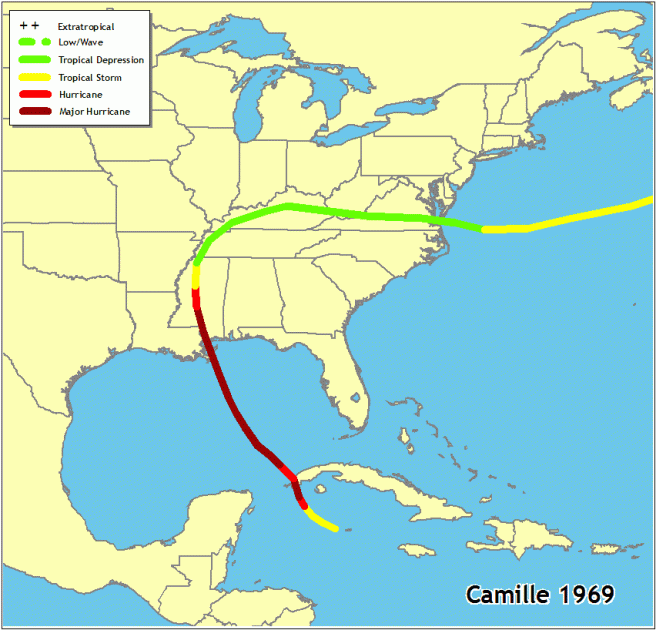
In August of 1969 we were visiting grandparents in central Mississippi when I had my first experience with the seriousness of a hurricane. One morning several days before we were scheduled to leave my father announced that we were leaving as quickly as possible. He had been watching the television reports and listening to the radio to monitor the storm forming in the Gulf (this is how we got information in 1969!). We would reach the safety of Texas shortly before Hurricane Camille came ashore. Camille had developed quickly and I’ve always been glad that my weather smart father knew we needed to leave. Thankfully, my grandparents had only heavy rain and wind by the time Camille reached them two hundred miles inland.
The real fun for me began in the mid-1980’s when I picked up a paper tracking map from the local grocery store. Yes, a paper map of the Atlantic Ocean and Gulf of Mexico with lattitude and longitude graphed over it. Each year I would stalk the weather reports on television waiting for the new coordinates to be released; if they were delayed in reporting I was always frustrated. This was how we got information in those days! I always used pencil in case a storm fizzled out so I could erase the track and re-use the map.
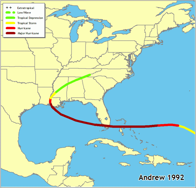
Over the years I tracked many storms including Hugo and Andrew. Andrew was the most memorable to me as my hubby was working in Biloxi as the storm was churning across the Atlantic on a course for Biloxi. After preparations were completed for the business where he worked he and his co-workers went inland to a hotel. He called me before they left and told me it would probably be several days before he had phone access (this was 1992, long before cell phones). To my surprise he called a day or two later and was back in Biloxi. I was surprised, but he explained that the local people all knew when the storm crossed a certain parallel and turned a certain way it would not come to Biloxi and that was what had happened. Andrew crossed the tip of Florida and continued across the Gulf before turning north into Louisiana. I kept that tracking chart for a long time!
Tracking hurricanes on a paper map was fun, but I am very pleased today to use modern technology supplied by the National Hurrican Center. Data is available and accessible at all times and is much more detailed that what I ever got from watching local television stations and the Weather Channel. Forecasting techniques have advanced and the accuracy of predicting a storm’s potential to develop as well as its track are very accurate. However, the most fascinating part is that the storms often have a mind of their own and can change course abruptly.
Reliable hurricane record keeping began in 1851, but after the massive 1900 Galveston storm hurricane tracking and storm preparations became a priority. The lose of life in that storm is estimated to be between 8,000 and 12,000 people. Sadly, there was still little knowledge about hurricanes and understanding their affect on weather patterns. Several years ago the Weather Channel produced an episode of When Weather Changed History about this powerful storm, click on the link to watch Galveston Hurricane 1900.
Yes, I’m fascinated, but very respectful of their power and their ability to destroy life and property. I’ve always wished I could be in a safe, protective bubble and “ride one out”, just to witness the power of nature!

Hello Beth – long time no see. I found this post on hurricanes very interesting. I have never been in one and I hope never to be. I feel sorry for those that lose everything to these storms.
Living in Arkansas we seldom get much from storms along the coastal areas. Thanks for sharing. Your father sounds like a very smart man when it comes to knowing when to stay home and when to leave during hurricane season..
LikeLiked by 1 person